Ever wonder how scientists know so much about the migratory patterns of birds? In our technology age, it’s by advanced tagging and tracking systems. Much like they do with sharks, this type of tracking allows wildlife researchers to know where the birds are moving, when, and for how long. Tracking towers are then set up to locate and follow the birds, gathering location information being transmitted by the tagged birds.
One such tracking device, the new Motus Wildlife Tracking tower, was unveiled at Caesars Head State Park recently. It is specifically being used to capture data from tagged birds native to our local area and follow their migratory patterns. Although there are towers such as this in Columbia and the lower part of South Carolina, this is the first in the Upstate.
How it works:
The tower works by using radio signals to track the real-time movements of the local wildlife within about 10 km (6.2 miles) of the peak at Caesars Head. The researchers can then use this collected data to provide real-time migration logs on specific species of interest. There are many birds that can be tracked but the current focus will be on those such as Painted Buntings, Swainson’s Warblers, and even shorebirds like Red Knots. 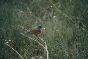
To learn more about this project, you can view a video by the Motus Wildlife Tracking System on Youtube, or embedded below. Also, you can visit the Motus website for additional information about this system as well as the importance of bird conservation.
<iframe width=”1280″ height=”720″ src=”https://www.youtube.com/embed/kqx85gL2Dek” title=”YouTube video player” frameborder=”0″ allow=”accelerometer; autoplay; clipboard-write; encrypted-media; gyroscope; picture-in-picture” allowfullscreen></iframe>
 See for yourself:
The Motus Wildlife Tracking System website also has real-time data that you can view yourself! Interested in viewing what information is coming out of Caesars Head State Park? Click on the Explore Data tab on the top menu bar. You can then click on Receiver Locations and scroll in on the interactive map to find the dot nearest to us, which will be from the state park. Given the newness of this tower, the data hasn’t yet started to appear, but you can look at other locations in the Carolinas. If you want to find what information they’ve gathered on specific bird species, you can view those by clicking on the Species Tagged link under the same Explore Data tab. You can click on a species, and click your way through to a specific bird being tagged, viewing its specific migration path by click on “view on a map” like the following wren that flew its way to Nova Scotia all the way from Rhode Island back in 2015 https://motus.org/data/track?tagDeploymentId=281. That was one fit little bird.
Recent Comments